











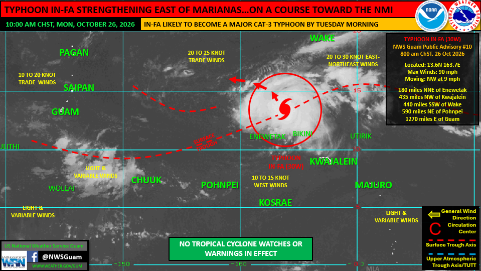
Typhoon In-fa is strengthening east of the Marianas and is currently forecast to track toward the Northern Mariana Islands late this week as a major storm, according to officials from the National Weather Service Weather Forecast Office Guam.
As of Monday morning, the category-1 typhoon packed maximum sustained winds of 90 mph while moving northwest at 9 mph. The system is located well east of Guam and near the northern Marshall Islands. Weather officials expect In-fa to slow down overnight before turning west-northwestward and accelerating toward the region.
Current forecast models project the storm to intensify into a category-3 typhoon by Tuesday morning and potentially reach category-4 intensity as it passes near Pagan late Friday.
Although the center of the track currently targets the northern islands of the NMI, weather authorities emphasized that track and timing shifts remain likely over the coming days. Saipan remains within the southern edge of the forecast cone of uncertainty, meaning any southward shift could bring severe weather closer to the southern inhabited islands.
No tropical storm or typhoon watches or warnings are in effect for Guam or the NMI at this time.
Weather officials also addressed regional rumors regarding additional storm threats across the Pacific. Landon Aydlett, warning coordination meteorologist for the NWS Guam, clarified that Tropical Storm Olana, currently tracking eastward across the International Date Line in the Central Pacific, poses no threat to the NMI, the Republic of the Marshall Islands, or the Federated States of Micronesia.
Residents and business operations throughout the NMI are advised to monitor official weather updates closely as the system approaches. mbj